Satellite Remote Sensing for Climate Change
With new satellite constellations being launched, covering a spectral range of 0.4 µm to 14.0 µm (micron), and availability of Artificial Intelligence (AI), Machine Learning (ML), Computer Vision (CV) algorithms and management systems, industrial and natural emissions can be detected to monitor climate change to understand and observe the changes in our weather and environment.
Satellite remote sensing can contribute to a wide array of global climate-change related application areas for vegetation and ecosystem dynamics including CO2 Carbon Dioxide detection, CO4 methane detection, disaster monitoring, weather patterns, land surface climatology, hydrology, and land cover change.
Methane Plume (CO4) Detection by NASA's AVIRIS-NG Satellite - Summer 2020
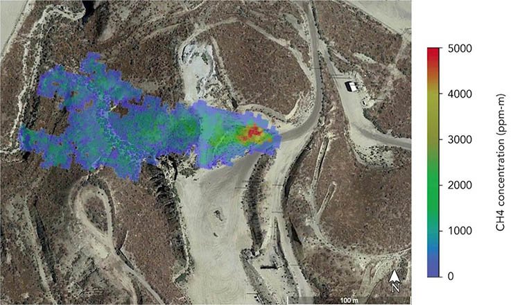
Copyright © NASA/JPL-Caltech. All rights reserved.
Carbon Mapper Satellite Sensor (30m)
The increase of carbon footprints around the globe has resulted in higher temperatures due to greenhouse gas emissions and is having a major effect on the environment and threatening species everywhere. Two (2) Carbon Mapper Satellite sensors, are expected to be launched in 2023 by Planet Labs PBC, under the Carbon Mapper nonprofit organization and its partners – the State of California, NASA’s Jet Propulsion Laboratory (NASA JPL), Planet, the University of Arizona, Arizona State University (ASU), High Tide Foundation and Rocky Mountain Institute (RMI). The Carbon Mapper satellite constellation, with a spatial resolution of 30m, can detect CO2 gases and CO4 methane that are being released in the atmosphere in critical areas.
Carbon Mapper will also provide an additional 25 + other carbon and environmental indicators to resolve and to reduce the amount of emissions in our air and global ecosystems, utilizing a spectral range from 0.4 µm to 2.5 µm (micron).
This last century the demand for food, water, shelter, energy, and consumerism is threatening our natural resources, some by forces of nature, but the majority of issues by human activity contributing to the carbon footprint that is induced by keeping up with the demands of a growing population. The depletion of our natural resources are causing changes in our environment, our health, and our ecosystems.
There are billions of people living on this earth and most are living in high-density cities in countries around the world. Many countries are at risk of running out of necessary resources due to climate change, overpopulation, and disease. Food production is at most risk requiring the need to farm more land which results in deforestation, pollution, habitat loss of species, and lack of water for a growing population.
Observing climate change stressors in high denisity urban areas, transportation and many other industrial entities are critical to reducing the amount of greenhouse gases that are being released into the atmosphere. Monitoring soil moisture, weather patterns, population, vegetation, ice, and glacier stability in sensitive areas. Earth observation satellite sensors and AI/ML algorithms can produce models to detect, predict, and analyze the current situation and look into our future outcome in climate change.
Reflected and Thermal InfraRed Spectral Range
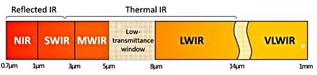
Copyright © IntechOpen. All rights reserved
WorldView-2 (0.5m) Satellite Image of Oil Refinery
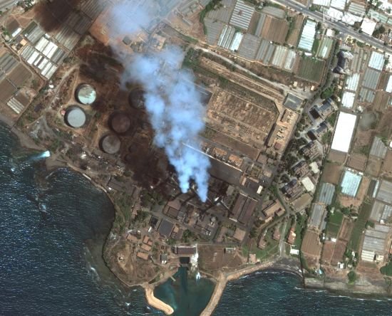
Copyright © MAXAR. All rights reserved.
Satellite Remote Sensing and Aritificial Intelligence (AI) for Climate Change
The latest innovation to aid in predicting global climate change has been from the utilization of AI and ML algorithms and management systems. AI for climate change takes advantage of ML and Computer Vision (CV) models. Using imagery collected by satellites, aircraft or unmanned aerial vehicles (UAV) can predict behavior and provide near real-time reports of climate change due to the increase of CO4 methane and CO2 being released into our atmosphere. This state-of-the-art technology enables scientists to predict the changes and provide models to monitor, manage, and quantify the amount of green house gases being released that can aid in reducing the acceleration of weather patterns.
Satellite Imaging Corporation (SIC) can provide satellite image datasets for vegetation and land cover use, monitoring change detection and climate change by updating a projected area and incorporating a more recent image to determine the changes over a period of time.
Himalayas Mountains - Landsat 5, 7, and 8 (15m) 3D DEM - Normalized Difference Vegetation Index ( NDVI ) 1993 - 2017
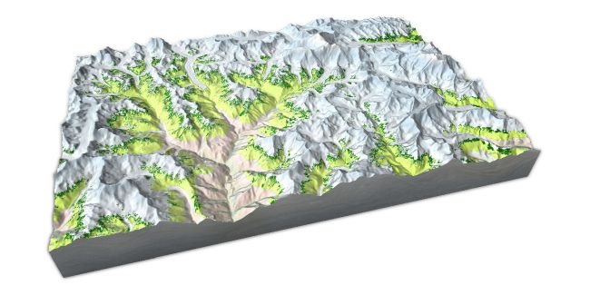
Copyright © NASA. All rights reserved.


