Homeland Security Mapping
Satellite Imaging Corporation (SIC) provides geospatial products and services for government agencies and defense contractors for various applications in Defense and Intelligence Mapping.
Every community has facilities that are critical, from emergency response to safety operations. GIS applications such as orthorectified topographic base maps, remote sensing data, and vector layers (i.e., roads, rivers, buildings) are now the basis for assessing security risks and modeling emergency scenarios. Satellite imagery and GIS map data are critical to homeland security because it enables managers, supervisors, and emergency personnel to integrate multiple information types into a common visual application. By utilizing deep learning processing techniques, such as convolutional neural network (CNN) algorithms, for temporal satellite imagery analysis, timely results are obtained and provided to the users.
<1m Stereo IKONOS Satellite Image Data and 2m DSM
3D Flythrough of the Nuclear Facilities at Yongbyon (North Korea)
Click image to view 3D Flythrough Movie
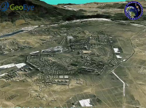
Copyright © MAXAR. 3D Flythrough processed by Satellite Imaging Corporation. All rights reserved.
Combining stereo satellite imagery and terrain elevation databases SIC can create stunning true-color 3D terrain visualization models of any location for flight training, battlefield management, mission rehearsal, research, and other activities which provide vital information for aerial mission planners and command information systems.
Detailed knowledge of the terrain is a key factor for successful military operations. Stereo satellite map data is a source of reliable, regularly updated information which gives a realistic and objective view of the terrain indispensable for mission planning.
Our data products are used in a variety of applications:
- Strategic, tactical, and operations
- Combat missions
- Route planning
- Training and simulations
- Air, sea, and land navigation
- Command, control, communications, and intelligence operations
- Modeling and simulation


